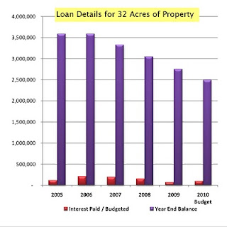
Since March 31 marked the fifth anniversary of the previous Council’s purchase of 32 acres of property at the corner of Rice Road and Highway #20, I want to provide you with an update.
You may recall that in January 2005, the previous Council decided to purchase the 32 acres for nearly $3.53 million – an average of $110,000 per acre – from Westerra Equities Corp. As of December 31, 2009, the Town has paid $736,875 in interest and $838,098 in principal with $2.75 million owing on the loan. (For detailed financial information, please click here.)
That purchase was based on a December 2004 appraisal that stated its valuation followed “Extraordinary Assumptions.”
For example, the appraisal assumed that the site possessed full water and sewer servicing. In reality, water and sewers weren’t available until the fall of 2007.
The major “Extraordinary Assumption”, however, appraised the property as if it contained 8.2 acres of commercial land along Highway 20, and 23.4 acres of business park lands. In reality, the entire property was – and still is – officially designated “business park.” The Town paid approximately $91,000 per acre for the business park lands and $188,000 per acre for the faux-Commercial lands.
Can’t Council just fix the zoning, you ask? In this case, it’s quite complicated.
You see, the previous Council almost changed the property’s designation in April 2006 when it almost approved the Town’s East Fonthill Secondary Plan. (The East Fonthill Secondary Plan is a detailed statutory planning exercise that covers most property east of Station Street from Highway 20 along Rice Road to south of Merritt). Instead they accepted the majority Landowners Group demand and stopped the planning work.

Then, just as had been warned, the Province changed all municipal planning in June 2006. Among many other changes, the Province locked all “business park” lands – including the Town’s.
Then, in September 2006, Council relinquished the Secondary Plan process to the Landowner’s Group.
So, how is this Council moving forward?
This Council hired an expert to work directly with the Landowner’s Group to complete the Secondary Plan; the Group began presenting final drafts to the Town last week.
Then, at an Official Plan open house on April 27, the Town will show the rationale to unlock the Province’s “business park” rules.
Finally, the results of a 2009 Special Council workshop for the development of the Town-owned lands and the final report by the Recreational Facilities Committee are both expected to come forward this spring.
These next steps will be critical to help Council finally decide how best to redesignate, sell, and make use of the lands.


